


Tropical Storm Imelda formed Sunday in the western Atlantic and is forecast to strengthen over the next few days, bringing the threat of torrential rainfall to portions of the Southeastern U.S. early this week, according to the Miami-based National Hurricane Center.
Imelda, the ninth named storm of the 2025 Atlantic hurricane season, is forecast to become a hurricane by late Monday or Tuesday.
Tropical Storm Imelda forecast maps
As of 2 p.m. EDT Sunday afternoon, Imelda was located about 95 miles west-northwest of the Central Bahamas, with maximum sustained winds of 40 mph.
CBS News Miami 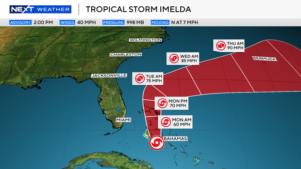
Imelda’s center was expected to cross over the central and northwestern Bahamas Sunday, before eventually making its approach to the Southeast coastline. The Bahamas and Cuba are already receiving heavy rains from the system.
“Steady strengthening is forecast during the next several days,” the hurricane center said.
NOAA/National Hurricane Center 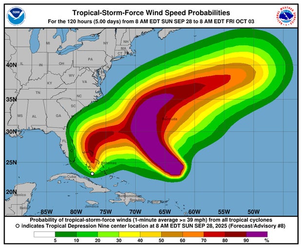
Imelda is forecast to bring up to 8 inches of rain to Cuba and the Bahamas, with the possibility of flash and urban flooding and mudslides.
Portions of Florida’s East Coast, north to the eastern Carolinas, could see anywhere from 3 to 10 inches of rain, the hurricane center said.
Tropical storm warnings and watches for Imelda
A tropical storm warning was in place for the Central Bahamas, including Cat Island, the Exumas, Long Island, Rum Cay and San Salvador, portions of the northwestern Bahamas, including Eleuthera, New Providence, the Abacos, Berry Islands, Andros Island and Grand Bahama Island.
A tropical storm watch is in effect for the East Coast of Florida, from the Palm Beach-Martin County line to the Flagler-Volusia County line. A ‘watch’ means tropical storm conditions are possible in the area within about 48 hours.
Imelda follows Hurricane Humberto
Imelda comes on the heels of Hurricane Humberto, which rapidly intensified to a Category 5 hurricane over the Atlantic on Saturday but is not expected to reach land.
Forecasters said there was a small possibility that Imelda could collide with the Humberto, which is churning to its east, creating what is known as a Fujiwhara effect, a rare phenomenon in which two different storms merge and become entangled around a newly formed, common center. However, they said it was not considered a likely outcome in this case.
U.S. officials brace for Imelda
South Carolina Gov. Henry McMaster issued a state of emergency ahead of Imelda on Friday, writing that “while the storm’s arrival, speed, and intensity remain hard to predict, we do know that it will bring significant wind, heavy rainfall, and flooding across the ENTIRE state of South Carolina.”
On Saturday, McMaster wrote on social media that the forecast had “improved” but that Imelda “still poses a significant threat to our entire state.”
The Federal Emergency Management Agency said Friday it is also preparing for Imelda’s potential impact. While the FEMA National Response Coordination Center has not yet been activated, FEMA is planning the potential requirements for staging bases in the Southeast and Mid-Atlantic that would be stocked with meals, water and generators if needed.
contributed to this report.

0 Comments